|
|
|
|
|
|
|
|
|
|
|
|
Ocean Currents & Tides
Tides are the periodic motion of the waters of the sea due to the changes of attractive forces of the Moon and Sun upon the rotating Earth.
Why do we care about tides as mariners? A high tide can provide enough water for a ship to clear a bar and enter a port. The low tide may limit the amount of water available and prevent you from entering port.
Tidal currents accompany the rise and fall of the tide.
Basic Definition
Tide - vertical rise and fall of the water - High and Low Tide (water) or Rise and Fall of the tide
Tidal Current - the horizontal flow - Ebb and Flood
Flood - the current is flowing toward land, into the harbor
Ebb - the current is flowing away from the land, out of the harbor
The rise and fall of the tide is not linear. It starts slow, then builds up speed, when the tide has risen or fallen about half way it slows down until it reaches the peak or valley when it stops. The Stand is the point where the rise or fall slows down completely before it reverses. The stand is defined as the point of the tide where there is no apparent vertical motion.
Range of tide - the difference in height between consecutive high and low water.
Types of tides
Semidiurnal - two high tides & two low tides per day. The heights of the two highs are very close as well as the two lows, not much variation in height for that particular day. The stand happens approximately every 6 hours. East Coast of the United States.
Diurnal - a single high and a single low tide per tidal day. North Coast of the Gulf of Mexico.
Mixed Tide - Characterized by a large inequality in the high water heights, low water heights, or in both. There are usually two high and two low waters each day, but occasionally the tide may become diurnal. West Coast of the United States.
A tide may be defined as a specific type but all types vary to some extent throughout the month with the cycles of the moon. The attractive forces of both the sun and the moon cause the changes.
Perigee - the moon's orbit is closest to the Earth.
Apogee - the moon's orbit is farthest from the Earth.
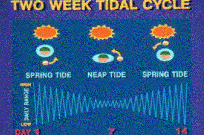
When the Moon is closest to the Earth (perigee) it causes a tidal bulge because of the large attractive forces between the Earth and the Moon. This same bulge happens when the Moon is a Full or New Moon, when the Earth, Moon and Sun are in line, called Spring Tide. Spring tides and Perigean tides are more extreme than the normal tides. The highs are higher and the lows are lower.
When the Moon is farthest from the Earth (apogee) there is less attractive force between the Earth and the Moon. This causes the tides to be less severe and has the same effects when the Moon is at the 1st or 3rd quarter which is called a Neap Tide. The highs aren't as high as during the rest of the month and the lows aren't as low.
Tidal Day is equal to a lunar day, which is 24h50m. The lunar day is the time between consecutive transits of the moon.
Chart Sounding Datum (a.k.a. Chart Datum) - The tidal datum to which soundings and drying heights on a chart are referred. It is usually taken to correspond to a low water stage of a tide.
Datum is any numerical or geometrical quantity or set of such quantities, which may serve as a reference or base for other quantities.
Sounding is a measured or charted depth of water or the measurement of such depth.
The following datum's have been averages over a 19-year period
* Mean Low Water - MLW - the average of all the low tides. This was used for years on all Atlantic & Gulf Coast Charts as well as most DMA charts. This is being discontinued as the DMA charts are discontinued (replaced by NOS charts.)
* Mean Lower Low Water - MLLW - The average of only the lower of the two daily tides. This was always used on the Pacific Coast Charts & is now used by all NOS Charts.
* Mean Low Water Spring - MLWS - The low water at spring tide
* Mean Lower Low Water Spring - MLLWS - the average of the lower of the two daily low tides at springs. Most BA charts use one of the spring datum's.
Current is a horizontal movement of water.
Set is the direction toward which a current moves.
Drift is the speed of the current.
Wind causes waves, swells and eventually currents. Local wind creates friction on the surface of the ocean, which forms waves. Distant winds, usually storm winds, cause swells. Whenever a wind blows in the same direction for more than 12 hours a current is formed. The current carries the waves away from the storm, which develops the swells in distant areas.
Flood - the current is flowing toward land, into the harbor
Ebb - the current is flowing away from the land, out of the harbor
Slack water - an instant or short period of time of little or no current at the reversal of the current.
Types of currents
Wind Driven Currents - The stress of wind blowing across the sea causes a surface layer of water to move.
Ocean Currents - wind driven currents that travel over entire oceans and have developed from the prevailing winds over centuries. The Trade winds are caused by the rotation of the Earth that pushes the air to the West (NE winds in the Northern Hemisphere & SE winds in the Southern Hemisphere.) The persistent winds form the current. Land gets in the way of the current so the needs to be deflected somewhere. The Coriolis Force dictates where the current gets deflected. In the Northern Hemisphere, the current is deflected in a clockwise direction. In the Southern Hemisphere, the current is deflected in a Counterclockwise direction. These wind driven gyres are not symmetrical. Along the Western Boundary of the oceans, currents are narrower, stronger and deeper, often following a meandering course. These currents are sometimes called streams. In contrast, currents in the mid-ocean and at the Eastern Boundary are often broad, shallow and slow moving. Sometimes these currents are called drift currents.
Tidal Current - caused by gravitational interactions between the sun, moon and the Earth and are a part of the same movement of the sea that is manifested in the vertical rise and fall, called Tide. Tidal currents are known as tidal streams in the UK.
Hydraulic current - A current in a channel caused by a difference in the surface level at the two ends. Such a current may be expected in a strait connecting two bodies of water in which the tides differ in time and range. (East River - Long Island Sound to New York Harbor)
Rotary Current - A tidal current that flows continuously, with the direction of flow changing through 360 degrees during the tidal period. These currents are usually found offshore where any barriers do not restrict the direction of flow. The Coriolis Force causes the tendency for the rotation so it is clockwise in the Northern Hemisphere & Counterclockwise in the Southern Hemisphere. The spied of the current will vary throughout the rotation. There will be a peak or maximum speed twice, opposite each other through the cycle and the minimum would be 90 degrees from the maximum.
Nontidal Current - any current that is not caused by tidal flow.
Periodic Current - the speed or direction changes cyclically at somewhat regular intervals, such as tidal current.
Seasonal Current - changes in speed and direction are due to seasonal winds.
Ocean currents are semi-permanent. They experience little periodic or seasonal change.
Coastal Current - flows roughly parallel to the coast, outside the surf zone.
Longshore Current - flows parallel to the coast, inside the surf zone. This is generated by waves striking the beach at an angle.
Offshore Current - any current some distance from the shore.
Inshore Current - any current close to the shore.
Sargasso Sea - The West Central Region of the subtropical gyre of the North Atlantic Ocean. It is bounded by the North Atlantic, Canary, Atlantic North Equatorial, and Antilles Currents, and the Gulf Stream. It is characterized by the absence of well-marked currents and by large quantities of Sargassum, or gulfweed. This is the nursery of the sea. Many animals go there to give birth or grow up, like eels and sea turtles.
|
|
Ocean Currents
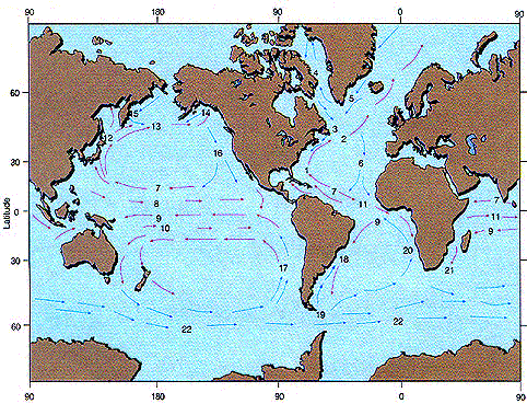
Click on the picture for more info!
The Gulf Stream - the North flowing current off the East Coast of the United States. It starts where the Florida Current and Antilles Current meet North of Grand Bahama Island (where we went on cruise this year.) The strongest portion of the stream is from Florida to Cape Hatteras, NC. It is distinguished by deep indigo-blue color; this contrasts with the dull green color that surrounds the stream. Warm water is carried up the Gulf Stream from the Warm Caribbean Waters. When the Gulf Stream encounters the cold water of the Labrador Current, in the vicinity of the Grand Banks (good swordfish grounds - The Perfect Storm), there is little mixing of the waters. Instead, the junction is marked by a sharp change of temperature and is known as the cold wall. When the warm water encounters the cold air, convection fog is created. This is also known as frost smoke.
|
Gulf Stream
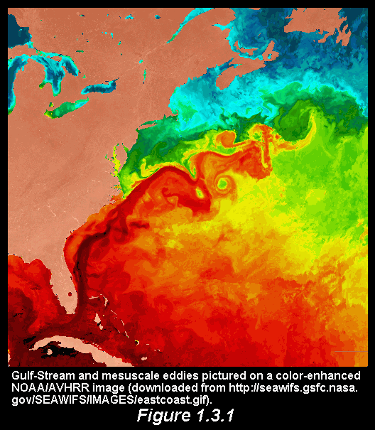
Know everything there is to know about the Gulf Stream! |
|
Sargasso Sea
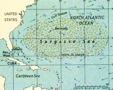
Click on the picture for more information! |
Click on the picture for a slide show on tides.
Use the < > arrows on the screen to peoceed to the next slide.
This is a great slide show! |
|
|
|
|
|
|