Lateral Marks - Region B (U.S. System)
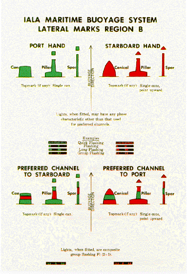
Region B is used for lateral marks in the United States. Lateral marks are Aids to Navigation that are used to mark the edge of channels.
Memory Aids for Region B -
"Even Nuns Blush" which means that the nun (cone) shaped buoys ared even numbered and red in color.
"Red Right Returning from sea" which means you keep the red buoys to the right of your vessel when you are coming in from sea.
Region A is used in England. The color and numbers are reversed. The shape stays the same.
Remember - a "Bifurcation" is a fork in the road, a place where the channel splits into two separate channels.
The preferred channel markers are lateral marks that tell you the better channel to go down. The top stripe will dictate the color of the light and the side of your vessel that you have to keep it to. It is kept to the same side as any lateral mark would.
In Region B - coming in from sea, you see R-G-R, cone shaped buoy. It has a red light on it, flashing "Group Composite 2+1." You would keep it to the right, starboard, b/c it is mainly red. That means you would go to the left or port. This means the prefered channel is to Port. |
Intercoastal Waterway Lateral Marks
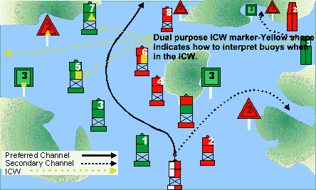
The Intercoastal Waterway is a protected way for boats to travel from Maine to Florida without going into the ocean. As a mariner enters the ICW from sea they will notice a yellow square or triangle painted on the lateral marks. This is only seen at the intersection of the ocean and ICW. The ICW follows the same rules as all the other lateral marks in the U.S (IALA Region B.)
Lateral marks are numbered around the U.S and islands in a clockwise manner. The ICW numbering starts in Maine and the numbers increase as you travel down the coast. The same holds true for offshore lateral marks.
On the West Coast of the U.S. there is no equivelent ICW. The offshore lateral marks will start their numbering in Southern California and work its way up to Washington then over to Alaska.
Green Buoys traveling up or down the coast will always be closer to the ocean & the red, closer to the coast.
|
|
Cardinal Marks
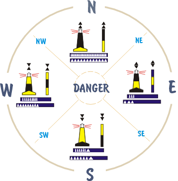
Know this diagram for the final!
These marks are not used in U.S. waters.
Know the Topmark, color pattern and flash pattern of each buoy. Always a white light!
Memory Aid - "West is a wine glass" to remember the topmark
"All arrows point to black" to remember the color scheme
What marks are used in U.S. waters to show the location of obstructions?
|
Which cardinal mark is this?
Click on buoy for more information!
This is the Western Cardinal Mark which means there is safe water to the West of this mark. |
|
Chart Symbols for buoys
This shows some chart symbols and what the buoy would look like. What is missing?
Isolated Danger Marks and Special Marks. |
IALA Regions of the World
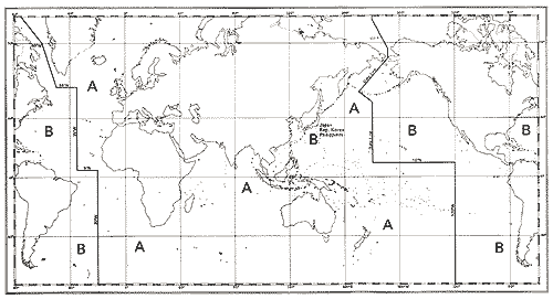
The world is broken up into 2 regions A & B basically because no one could totally agree on what the colors of buoys should be. In 1980, they buoyage system that we use today was established.
The IALA Regions only affect Lateral Marks - the markers that define the channels. They are red or green buoys or beacons.
The U.S. uses Region B.
The International Association of Lighthouse Authorities (IALA) established in 1957, gathers together marine aids to navigation authorities, manufacturers and consultants from all parts of the world and offers them the opportunity to compare their experiences and achievements. IALA is encouraging its members to work together in a common effort to harmonise aids to navigation world-wide and to ensure that the movement of vessels are safe, expeditious and cost effective. |
|
Isolated Danger Mark
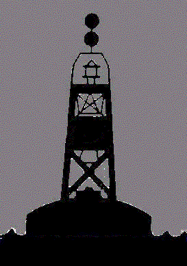
Erected on or moored on or above an isolated danger of limited extent which has navigable water all around it.
2 black sphere topmarks
Black and Red horizontal stripes
pillar or spar
when lighted, white with a flashing group of 2 flashes
Click on the picture to learn more about buoys! |
|
|
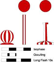
Safe Water Mark
Used to indicate that there is safe navigable water all around the mark. May be used as a center line, mid-channel or landfall (sea) buoy. The Pilot station is often found near this type of mark.
one red sphere topmark, if fitted
Red and white vertical stripes
spherical, pillar or spar
white light - occulting, isophase, single long flash or Morse A (.-) |
|
|
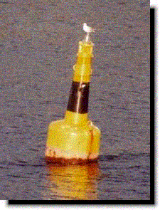
Special Mark
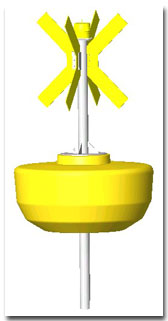
May be used to indicate a special area or feature which is apparent by refering to a chart, Sailing Directions or Notice to Mariners. Uses include:
Ocean Data Acquisition System (ODAS) buoy
Traffic Separation Scheme marks
Spoil ground marks
Military exercise zone marks
Cable or pipeline marks, inc. outfall pipes
Recreation zone marks
Yellow in color
Yellow light, flash pattern anything characteristic that is not assigned to a white light
Topmark X
shape - any of the five (can, nun, sphere, pillar, spar) |
Single Point Mooring
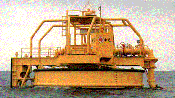
This Special Mark is used at offshore oil terminals. A ship attaches an anchor chain from the SPM (Single Point Mooring) and a tug pulls the stern of the vessel to keep the ship in place. Cargo hoses are hooked up to the vessel from the buoy where the hose attaches to underwater oil pipelines. This allows the ship to load and discharge cargo without tying up to a dock. |
|
ODAS Buoy
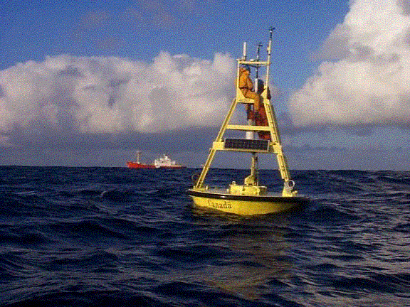
ODAS - Ocean Data Acquisition System
These buoys are special marks. The are usually Large Navigation Buoys (LNB) because they are located well offshore in areas where buoys are not often found. They also contain large amounts of scientific equipment aboard. These buoys are weather buoys that monitor wave height, wind, temperature, currents, etc.
For more information on ODAS buoys click on the picture. |
|
|