- The surface of the Earth is a sphere and charts are flat surfaces. It is impossible to transfer the features on a sphere to a flat surface without distorting the features. In making navigation charts, the chart maker must flatten out the surface of the Earth to put it on a plane. The process is known as Chart Projection.
Terms we must know before learning the types of projections:
Projection - the extension of lines or planes to intersect a given surface; the transfer of a point from one surface to a corresponding position on another surface by graphical or analytical means.
Map Projection - a systematic drawing of lines on a plane surface to represent the parallels of latitude ant the meridians of longitude of the Earth or a section of the Earth. A map projection may be established by analytical computation or may be constructed geometrically.
Tangent - meeting a curve or surface in a single point if a sufficiently small interval is considered.
Plane - a surface of such nature that a strait line joining 2 of its points lies wholly in the surface (a flat surface).
The chart maker starts with a Developable Surface that is the area of the Earth that can be flattened to form the plane. There are different ways that the surface of the Earth can be flattened to make a chart. Each method to project the surface of the Earth onto a chart has its own advantages and disadvantages. The smaller the scale, the more noticeable the difference between the different chart projections. On the larger scale charts, like harbor charts, all the projections are practically identical.
When choosing the type of chart projection you are going to use for navigation, you will be looking for certain desirable properties. These properties are:
- True shape of physical features
- Correct angular relationship.
- Equal area, or the representation of areas in their correct relative proportions.
- Constant scale values for measuring distance.
- Great circles represented as strait lines.
- Rhumb lines represented as strait lines.
Many of these properties are mutually exclusive, i.e. a chart cannot represent both Rhumb lines and Great Circles as strait lines.
A projection with correct angular relationship will also have true shape of features so it is conformal & orthomorphic.
Conformal - Having correct angular representation.
Orthomorphic - Preserving the correct shape.
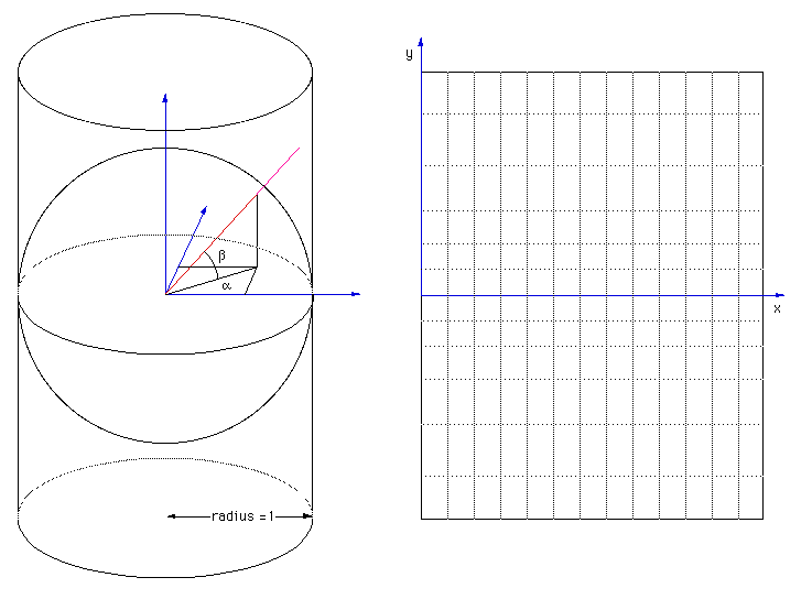
If the points on the surface of the Earth are projected from a single point, the projection is perspective or geometric.
Perspective - how the Earth looks from a certain point of view & is projected onto a plane to create an image on the chart.
Geometric
Mercator Projection
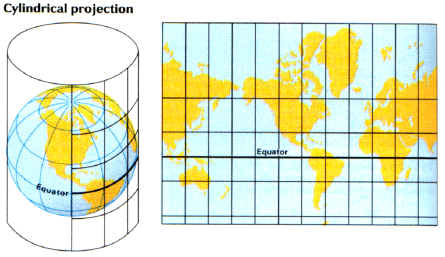
Cylindrical Projection
A cylinder is placed around the Earth and is tangent to the equator
The planes of the meridians are extended & they intersect the cylinder in a number of vertical lines.
The parallel lines of projection (longitude lines) are equidistant from each other unlike the terrestrial meridians. On the Earth, the meridians converge with increased latitude.
On the earth, the parallels of latitude form circles whose diameter decreases with increasing latitude.
On the cylinder, the parallels are shown perpendicular to the projected meridians. The cylinder maintains equal diameter throughout so there is distortion as to the diameter of the latitude circles.
Most common projection used for navigation is the Mercator projection which is classified as a Cylindrical Projection.
The cylinder is tangent along the equator.
The meridians and parallels are expanded at the same ratio with increased latitude.
The ratio is know as Meridional Parts - The length of a meridian, expressed in minutes of arc at the equator as a unit, constitutes the number of Meridional Parts corresponding to that latitude. (Used to make Mercator Projections & Mercator Sailings.)
The easy way to understand this projection is to first put the cylinder around the Earth touching the Equator. Then cut the Lines of Longitude and peal them away from the Earth starting at the Poles, like you would peal a bannana. Next, stretch the Longitudes so they become the same width apart as they were at the equator and stick them onto the cylinder. The Meridians are now parallel to each other on the cylinder but the shape of the land is distorted. It is as if you took silly putty to a Peanut's Comic and stretched Charlie Brown only side to side - you end up with a short, fat Charlie Brown. Now you have to stretch the Latitude on the Cylinder so that it gets stretched the same amount as the longitude did at a given location. You can stretch Charlie Brown Top to Bottom and end up with a larger version of the comic you pressed the silly putty to.
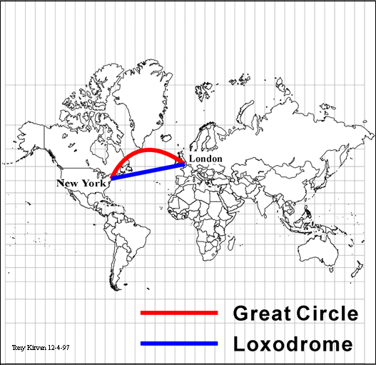
On the Mercator Projection the 60 nm between each minute of Latitude will look like it is much farther as you get away form the equator. The Parallels are spread out as they get away from the equator but in the real world each degree is the same distance apart.
As the distance from the equator increases, degrees of Latitude remain approximately the same length & the degrees of Longitude become increasingly shorter on the Earth.
Due to the mathematical expansion of the lat./long uses trig functions (secant) this projection cannot cover the poles. (Secant for 90 is infinity)
Generally, the distortion in the polar regions (above 70N and below 70S) caused by this projection is too great to be used for navigation.
The Meridians and Parallels are represented by strait lines that are perpendicular to each other.
Rhumb Lines are drawn strait
Great circles are arcs the curve toward the nearest pole.
Conformal, Orthomorphic and proportional. The didtance scale varies.
You can use the Latitude Scale to measure distance - be sure to use the Latitude Scale for the Latitude you are working on or the Mid-Latitude because of the lengthening of the parallels as you go toward the poles.
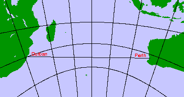
Lambert Conformal
First you must understand the basic conic projection.
Conic Projection -
Points on the surface of the Earth are transferred to a tangent cone.
When the axis of the cone coincides with the axis of the Earth, the parallels appear as arcs of circles and the meridians appear as strait or curved lines converging toward the nearest pole.
The point at which the cone is tangent, is know as the standard parallel.
A conic projection tangent to the equator is actually a cylindrical projection because the height of the vertex of the cone would be near infinity.
At the poles, the height of the cone is 0 so the cone becomes a plane.
The distance along any meridian between consecutive parallels is in correct relation to the distance on the earth
The scale is correct along any meridian and along the Standard Parallel.
Secant Conic or Conic Projection with 2 standard parallels -
Like the name says, there are 2 standard parallels that the cone is tangent to. This actually cuts into the earth.
The are between the standard parallels is compressed and the area beyond is expanded.
If the spacing of the parallels is altered, such that the distortion is the same along them as along the meridians, the projection becomes conformal. That is called a Lambert Conformal Projection.
Great Circles draw as strait lines - these charts are often used for aeronautical charts or used for polar navigation.
Gnomonic Chart Projection
A plane is placed tangent to the surface of the Earth.
The points are projected from the center of the Earth to the plane.
The projection is perspective - how the Earth looks from a certain point of view & is projected onto a plane to create an image on the chart.
Oblique Gnomonic-
A tangent plane is placed on the Earth. This projection is perspective from the center of the Earth. Basically, if you take a flashlight at the center of the Earth & shine it in the direction of the tangent plane, the land features will be the shadows that shine on the tangent plane.
This chart is often called a "Great Circle" Chart because its only use is to Plan Great Circle Voyages. Points along the track then get transfered to a Mercator Projection.
It is not conformal or orthomorphic.
Great circles plot as straight lines and rhumb lines plot as curves away from the pole.
The Meridian will appear as straight lines that converge at the poles as they do on the Earth. The Latitude lines, except the equator, will be curved.